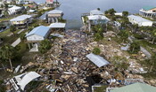
A web-based application that collects crowdsourced data to analyze floods and allow them to be addressed: this is what was developed by a team of researchers led by the University of South Florida (USF) who used the app to get essential data on Hurricanes Helene and Milton. The team of researchers led by Petersburg professor Barnali Dixon used the Cris-Hazard app to analyze real-time flooding in Pinellas County, which is home to 588 miles of coastline.
The app also received data from users in neighboring Hillsborough County during Hurricane Miltonwhich allowed the team to expand their research. The app, developed in collaboration with i researchers from Georgia Tech, combines geographic information and community crowdsourced data, such as fphoto and video, with near real-time flood data. Using dynamic modeling and mapping tools, including artificial intelligence, the app can identify and extract estimated water elevation from submitted images, allowing it to target authorities’ efforts.
“People used it to report what was happening in their backyard,” said Dixon, who is also executive director of USF’s Initiative on Coastal Adaptation and Resilience (iCar). “This information is their lived experience and we want to take that experience and obtain data from it using tools artificial intelligence which will process the images and determine the depth of the water. We can use that data to calibrate and validate models.”
In addition to the data provided to researchers, the images and videos are also accessible to other users, who can thus see where the floods occur and stay informed about dangers to the community. Dixon compares it to the real-time traffic app Waze, through which drivers can see traffic jams and where police activity is taking place along streets and highways. The new app, which offers an interactive user experience, is based on the existing Community Resiliency Information System (Cris), a website created in 2020 by iCar.
The Cris platform uses crowdsourced data to identify climate-related vulnerabilities in local communities. Residents can enter information about issues such as flooding and power outages. This information can then be used by policy makers and neighborhood leaders to make decisions about policies and resource allocation.
The data also allows emergency managers to identify areas with concentrations of people who require assistance with transportation or who depend on electricity for medical needs. “We have used the app at all of our community town halls,” said Erica Hall, executive director of the Florida Food Policy Council. “This will greatly help communities understand the connection between sea level rise, climate change, extreme heat and coastal flooding. “.
